Research team of the St. Petersburg Federal Research Center of the Russian Academy of Sciences (SPC RAS) has developed specialized software that combines into a unified information system the long-term data provided by the traffic police, cartographic and meteorological services. The above program allows for exercising analytical studies of traffic accidents to identify dangerous sections of urban roads and substantiate the reasons for the increased concentration of the accidents.
Daily, thousands of people around the world suffer of traffic accidents. Moreover, the cars and urban facilities are being significantly damaged. Currently various "Smart City" analytical systems are actively used in order to cut down a number of accidents, especially in big cities with heavy traffic. This approach presents one of the directions at the development of the Internet of Things concept, whose tasks include an integration of a great number of information flows for monitoring and supporting managerial decisions in regard to the city development. Such flows are available in any modern megalopolis (for instance, in the Russian Federation, main elements of "Smart City" systems are implemented in Moscow and St. Petersburg), and can be data from various weather sensors, surveillance cameras, as well as statistical information, information from urban social networks and much more.
Integration of data from heterogeneous sources is a complex research task, and its solution is approached by a great number of scientists. However, to date, in the world no single standard still exists for the "Smart City systems" development. Also, additionally to data integration itself, are required: the development of intermediate services able to link various databases and software products into a single system and provide a tool assuring an access to the integration outcomes, as well as, visual analytics tools.
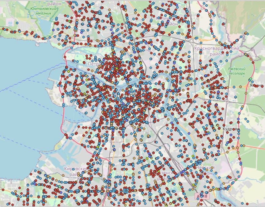
"We here suggest describing each data source in a special way via a so-called ontological representation. Under such a description, opens a possibility to arrange for search of common elements in data sources that can act as "anchors" for unification. This approach will let us combine data from heterogeneous data sources within one system. For the analysis convenience, an interface has been developed to visualize events on the city map at providing for filtering the traffic accidents by types, and viewing internal information on the accidents, along with data arriving from other sources. In this version of the service, it is also possible to perform automatic cluster analysis based on the geographical proximity of accident points with a subsequent analysis of traffic accidents’ types within a spatial cluster," says Nikolay Teslya, Senior Researcher at the Laboratory of Integrated Automation Systems of SPC RAS.
In the latest version, the service uses data provided by the traffic police archive on accidents in St. Petersburg from 2015 - 2021. The archive record cards contain depersonalized information about various circumstances of the accidents, like, number and types of vehicles, number of victims, drivers’ conditionы, illumination the intensity on the site, the road surface condition, and other. This information was linked to a source of weather history data that provides information details up to coordinates. Additionally, were available the information about the type of roads from various profile sites (the Openstreet map site was used in the study) and illumination data based on astronomical calculations of the sun position in the sky. These data were used both to verify the data in the traffic police record cards and to supplement them.
As for the streets in St. Petersburg, such an analysis exposed the most emergency areas located in Nevsky, Ligovsky and Kamennoostrovsky (at the intersection with Bolshoy Prospekt on the Petrogradskaya side) Avenues, as well as in Engels and Bolsheviks Avenues. In addition, the centers of traffic accidents are located at the sections of Moskovsky, Zanevsky Avenues, as well as on Vasilievsky Island close to the Smolenka River embankment. Among the most common causes of accidents are collisions of vehicles and collisions with pedestrians.
"The comprehensive analysis of events on the roads, that allowed our service to be performed, can possibly be used by city services at decisions making. For example, how to optimally arrange the traffic lights operation, install additional road signs, apply additional markings, organize safety islands for pedestrians, optimally place public transport stops or use any other infrastructure solutions to increase road safety. And the approach proposed for data processing can be applied in the future to information systems of various cities," explains Nikolai Teslya.
In the future, the system may involve information for dynamic analysis of various spheres of urban economy, for example, while planning the development of the city’s micro-districts, as well as during the construction and reconstruction of park areas in accordance with state regulations.