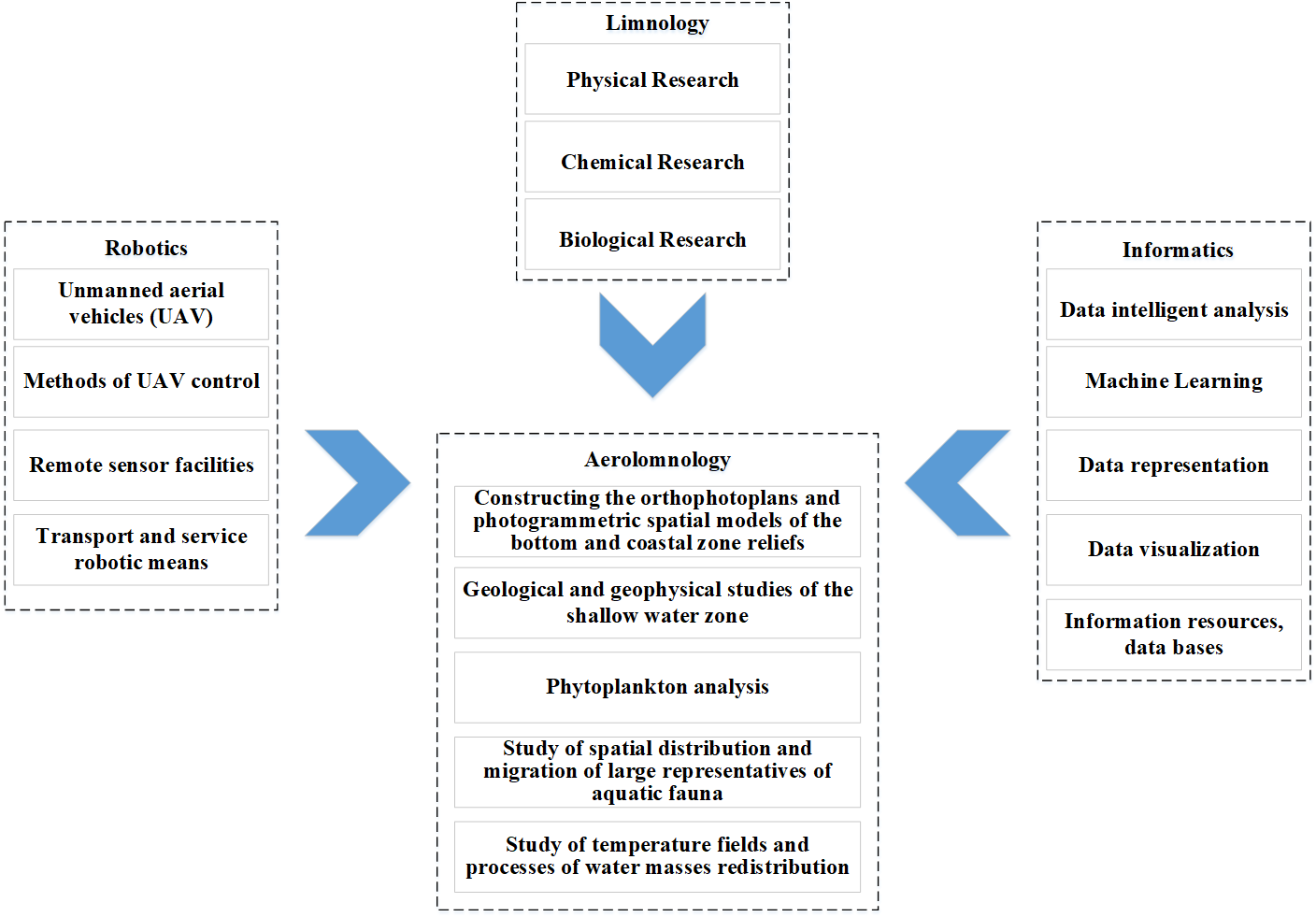
Researchers of the St. Petersburg Federal Research Center of the Russian Academy of Sciences (SPC RAS) have launched a new interdisciplinary scientific direction – aerolimnology. Within its framework, researchers propose an approach aimed at studying internal reservoirs (e.g., lakes and reservoirs), that comprehensively combines classical methods of limnology, methods of acquiring information by drones and sensor systems, as well as processing big data arrays as based on artificial intelligence technologies. The information acquired through aerolimnology methods can be used, in particular, to study bottom landscapes, aquatic organisms (like the Ladoga ringed seal or hydrobionts) and to search for minerals in hard-to-reach water areas. The concept of this new research direction is introduced in the scientific journal “Informatics and Automation”.
Water covers about 70% of the Earth's surface, besides, it plays a crucial role in the society’s functioning, being a source of water supply, irrigation and territories’ watering, thus, ensuring the industries’ functioning. Fresh water is one of the most valuable resources of mankind. Other mineral and biological resources contained in freshwater reservoirs may be of great interest to science and economics. According to geophysical data, ore-bearing structures can be traced in the water area of reservoirs, promising for the identification of new mineral deposits of strategic importance for the extractive industry development.
Over years of reservoirs’ study, several disciplines (limnology, hydrology, bottom geomorphology, etc.) and approaches have evolved to monitor the ecological state of water bodies, that implement methods, approaches and technical solutions of younger scientific fields, like, aerology or artificial intelligence technologies, to improve the efficiency of specific tasks’ solving. However, complex concepts binding together the methods of classical limnology and the latest achievements in the areas of application specifically of unmanned aerial vehicles (UAVs) and computer-aided systems for collecting and processing big arrays of data did not exist before.
"The study of reservoirs, which has been conducted in our center in recent years, shows that the transition of these studies to a qualitatively new level requires updating methods and approaches in an interdisciplinary manner. In response, we have developed a new scientific direction – aerolimnology. Its task is to conduct research at the junction of limnology (the whole spectrum of classical methods of studying reservoirs), robotics – the use of sensor systems for analyzing water bodies, UAVs for obtaining information during aerial surveys and measurements, as well as artificial intelligence technologies for solving problems quickly when processing a large amount of information," says Dina Sergeevna Dudakova, Candidate of Biological Sciences, Researcher of the Laboratory of Hydrobiology at IL RAS – SPC RAS.
To collect automatically a big amount of information, researchers propose to use special complexes developed at SPV RAS and composed of unmanned aerial vehicles with a payload, means for their delivery to a reservoir, and means ensuring their functioning. The payload can include various sensors: high-resolution video cameras, multispectral and infrared cameras, thermal imagers, spectrometers and magnetometers. Certification and detailing of acquired data in the bottom part is possible when apply an unmanned underwater Limnoscout apparatus developed at IL RAS – SPC RAS and furnished with similar sensors.
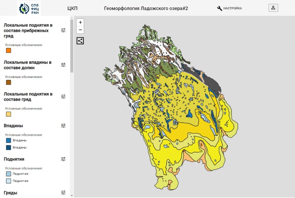
The information collected using such robots can be processed by artificial intelligence and data visualization systems. Thus, it is possible to simply map the reservoirs, as well as to build functional digital models (orthophotoplans) of the bottom and coastal zone reliefs, temperature regimes, geological structures of shallow waterы, including potentially ore-bearing ones. To work with such geoinformation systems SPC RAS established the "North-Western Center for Monitoring and Forecasting the Territories’ Development", that functions as a collective use center. So, with its help, scientists have already developed the maps for typification of the shores and geomorphology of Lake Ladoga, one of the most important reservoirs in the North-West of Russia
Aerolimnology methods also allow for tracking the distribution and migration of aquatic flora and fauna with high accuracy, in particular, the "blooming" of blue-green algae that cause serious environmental problems and deterioration of water quality. In addition, a digital model of any reservoir can account for the information on the location related historical events, information on the anthropogenic settlement of various coastal territories and the above impact on the state of the water area.
"Aerolimnology is of great interest for hydrobiologists, geologists, geophysicists, geomorphologists and many other professionals. Simultaneous data collection during aerial surveys of the water area and coastal territories, automated processing of large amounts of information allow for implementing a comprehensive, better accurate and effective approach to limnological research and find new knowledge at the junction of various scientific disciplines," says Vladimir Mikhailovich Anokhin, Doctor of Geographical Sciences, Leading Researcher of the Laboratory of Geography and Hydrology.
In the coming field season, it is planned to carry out large–scale work at Lake Ladoga – the largest of the European Great Lakes - as part of the development of aerolimnology based on UAVs developed in SPC RAS. While these works methodological approaches will be developed to use artificial intelligence technologies at processing the received complex data on the reservoir’s state.